CLIMATE AND SITE ANALYSIS
- GOAL:
- To become aware of energy efficient designs and construction that will save energy, cost less to operate and have less of a negative impact on the natural environment.
- OBJECTIVES:
- The student will demonstrate how knowledge of the natural environment and site details can affect the design process in building an energy efficient structure by conducting a site analysis.
- GLOSSARY:
- Physiography - The physical features of geography (site).
- Hydrology - Water movement on the site.
- Sensory Stimuli - Anything that stimulates the senses.
- Evapotranspiration - Vegetation pulling water up from the ground and evaporating it through its leaves, thus cooling the surrounding air.
- Prerequisite - Required beforehand.
- LESSON / INFORMATION:
- An understanding of the site and its environment is an integral part of a building program and is a prerequisite for good design. The building location on the site is basically established by one of two different view points. In one, the building location is given by the client. In the second and most advantageous, the building site is revealed by a thorough site analysis. A site analysis is the gateway to energy conscious design and environmental responsive architecture.
- Site analysis.
- Site analysis is a predesign research activity which focuses on existing and potential conditions on and around the building site. It is an inventory of the site factors and forces, and how they coexist and interact. The purpose of the analysis is to provide thorough information about the site assets and liabilities prior to starting the design process. Only in this way can concepts be developed that incorporate meaningful responses to the external conditions of the site.
- The typical site analysis includes the site location and size, neighborhood context, zoning, legal aspects, geology, physiography (natural and man-made features), hydrology, soils, vegetation, wildlife, climate, culture, pedestrian and vehicular circulation, access, utilities, historic factors, density, sensory stimuli, and any other factor deemed appropriate for the particular site.
- An understanding of these issues is important in designing a successful home that not only meets its internal responsibilities, but also relates well to its external environment. The home should last for many years, so the analysis of the site should take into account the site's existing and future problems and capabilities.
- The secret of using the site analysis is to design a good relationship between the building and the site itself. The building design should be in harmony with those beneficial site conditions and strive to save, reinforce, amplify, and improve on what is existing. The analysis will identify those site conditions which may be altered, eliminated, covered up, disguised or reformed. Basically, take advantage of the good things nature has to offer and protect against the bad aspects of the site. It is important to make these decisions deliberately and thoughtfully so that the effects of the building on the site are deliberate rather than accidental or incidental.
- All the factors needed for a complete site analysis can generally be categorized into aesthetic, cultural, and natural forces. Aesthetics has to do with what the person who will live on the site thinks is beautiful (the designer has the responsibility to educate the client to possibilities); culture is the background of the people living in the area; and the natural factors are the background of the environmental elements. For the purpose of energy-efficient design, natural factors need to be investigated and understood. The natural factors which are most important for thermal comfort in this analysis can be listed under climate and microclimate.
- Microclimate.
- Each specific site has its own unique climatic characteristics that need to be analyzed. The climatic aspects of the specific site or areas on the site are called the microclimate. The specific characteristics of the site are analyzed only after one has a good understanding of the macroclimate and general climatic characteristics which give an overview of the climate for your region. The microclimate must be studied not only for the natural elements, but for how any man-made elements, such as buildings and landscaping are affecting and/or will affect the site. For example, a windbreak that protects against the winter winds can change the microclimate of the site significantly (See Figure 1).
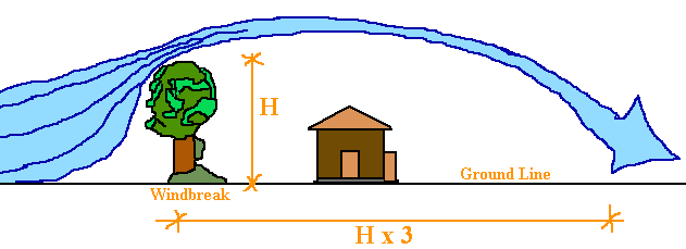
- Figure 1. Windbreak
- DISCUSSION QUESTIONS
- 1. What is the purpose of a site analysis?
- 2. What is included in a site analysis?
- 3. Factors affecting the site are grouped into what three categories? What do these three categories mean?
- 4. What is microclimate?
- 5. Besides studying natural elements in a microclimate study, what else must be considered?
- Climate Elements
- 1. Sun.
- The sun's movement on the site will be the same as that shown in the sun
diagrams in "Appendix C". Existing elements
(natural or man-made) on and around the site will have definite shading patterns.
Understanding those patterns can help in determining the building location
and configuration. For any given spot on the site, one can draw the existing
elements on the sun graph grid provided in "Appendix
C". Just as the sun path was plotted by knowing the azimuth and altitude
of the sun, existing site elements can also be drawn on the graph from any
one spot on the site. The diagram now shows which locations on the site receive
sunshine and shade. These same diagrams can be used to determine shadow patterns
to be drawn in plan.
- 2. Wind.
- Wind at the site and at different locations on the site can vary from the general wind data given for your area. A better understanding can be obtained by testing a true scale model of the site and buildings in a wind tunnel. When wind testing is not feasible, the designer can understand wind direction and speed by using five basic principles of air movement: velocity, direction, pressure, density and the venturi effect.
- First, as a result of the friction, air velocity is slower near the surface of the Earth. The cause of this reduction in velocity is the roughness of the ground, including contour changes and vegetation configuration. Ground wind velocities measured at the site are frequently much lower than those measured at the top of an airport tower. Likewise, exposed sites or buildings at altitudes higher than the airport tower are likely to experience much higher wind velocities.
- The second principle is that air tends to continue moving in the same direction when it encounters an obstruction. As a result it tends to flow around objects like water flows around a rock in a stream, rather than reflecting off the objects.
- Third, air flows from high-pressure to low-pressure areas. For example, cross ventilation is created by a positive pressure being built up on the windward side of a structure and a negative pressure being created on the leeward side.
- The fourth principle of air movement is convection, which involves the temperature and density of the air. For example, air flowing from a forested area to a meadow will tend to rise because air in the meadow is exposed to more solar radiation, making that air less warmer and dense (See Figure 2).
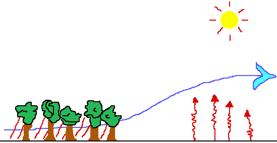
- Figure 2. Air Convection
- And finally, when the air flow is channeled and restricted, the pressure rises and the velocity increases. This is called the venturi effect (See Figure 3).
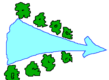
- Figure 3. Venturi Effect
- By using these principles and understanding how air moves and acts similar to a fluid, like water, we can visualize wind patterns on different sites and in different conditions.
- The wind pattern near large bodies of water is generated by the heat gain, heat loss, and heat storage variations between land and water. Water will have more stable temperatures. The wind is usually moving toward the land during the day when the land is heating up faster than the water and when the water is absorbing solar heat. At night the direction is reversed, with the breezes flowing from the land, as it cools, to the water, as it radiates stored heat to the night sky (See Figure 4).

- Figure 4.
- In valleys, the wind moves uphill during the day as the sun warms the air, causing it to become less dense. At night, air flows back down the valleys like a river, as it cools and becomes heavier. Pockets or lakes of this cool night air can be damned just as water can. This kind of wind pattern is similar to fog that forms in the cool air pockets of Louisiana (See Figure 5).

- Figure 5.
- One of the more important principles for ventilation in Louisiana is that high pressure and low pressure areas develop around an object that obstructs the path of air flow. Some of the aerodynamic principles that result are that the windward side usually creates a high pressure area as air stacks up and attempts to move around the object, creating a cavity of negative pressure (low pressure area) on the leeward side of the object. The velocity of air movement increases as it rushes around and over an object, and it can also create a dead air space on the leeward side of the object.
- 3. Humidity.
- Sites located near large bodies of water or rivers tend to be more humid than inland areas. Wind direction also affects humidity. Downwind from the water is more humid than up wind. Vegetation will also increase moisture in the air. Water vapor is a gas that occupies the same space with other gases that together constitute air. But in some ways, water vapor acts independently of the air. For any given temperature and degree of saturation, water vapor in the air exerts its own vapor pressure. It flows or migrates from areas of higher vapor pressure toward areas of lower vapor pressure in air or in materials. Moisture, driven by vapor pressure, can even travel through porous materials through which air cannot pass.
- 4. Temperature.
- The microclimate temperatures of the site may be different from the general data collected at the airport and can vary significantly at the site. Again, large bodies of water will tend to stabilize temperatures on the land adjacent to them. During a hard freeze in the False River area of Louisiana, most of the citrus trees within a quarter mile of the lake survived, while most of those outside that area did not.
- Through evapotranspiration, trees and other vegetation cool the air around them. A moist lawn is 10° to 15°F cooler than bare soil and 30°F cooler than unshaded asphalt. The shade temperature of a large tree can be 10° to 15°F cooler than the unshaded lawn during a summer day.
- Sites with a more southern slope will be warmer than a flat site because radiation from the sun is more perpendicular to its surface. Likewise, a northern sloping site would not receive as much radiation and would therefore be cooler.
- DISCUSSION QUESTIONS
-
- 1. What is the advantage of knowing the sun's pattern at a given site?
- 2. What are the five basic principles of air movement?
- 3. What affects the level of air velocity?
- 4. What happens when air encounters an obstruction?
- 5. What causes air to move? In what direction does it move?
- 6. What is convection?
- 7. What is the venturi effect?
- 8. With what can wind patterns be compared?
- 9. What affects the wind patterns near large bodies of water?
- 10. What are the wind patterns in valleys?
- 11. What two things affect the level of humidity?
- 12. What is water vapor?
- 13. How does water vapor move?
- 14. What affect does large bodies of water have on temperatures of adjacent lands?
- 15. What effect does trees and other vegetation have on temperatures around them?
- 16. Why will sites with a more southern slope be warmer than a flat site?
- ACTIVITY:
- 1. On a site plan of a given lot, conduct a site analysis. You should analyze the site's location within a city, community and neighborhood, the neighborhood context, size and zoning, legal matters, natural physical features, man-made features, circulation (vehicular and pedestrian), utilities, sensory aspects, human and cultural and climate.
- 2. It will take more than one visit to the site for a true analysis. Visit the site on a rainy day to see how it drains, at morning or afternoon peak traffic time, on the weekend, on a sunny day, on a night with a full moon, etc. It would also help to analyze the site during the summer and winter, but some things like different seasons need to be anticipated or the analysis will take forever to complete.
- 3. Put all the analytical remarks and/or graphics directly on a blueline print of the site.
- INFORMATION CHECK:
- Indicate whether the following statements are TRUE or FALSE.
- ____1. Understanding the site and its environment is an integral part of a building program and a prerequisite for good design.
- ____2. A site analysis should be conducted after the building is designed.
- ____3. The building design should reflect the site conditions and general climate conditions.
- ____4. Aesthetics has to do with what is beautiful.
- ____5. Only the natural factors need to be investigated for a complete site analysis.
- ____6. Microclimate has to do with the unique climate characteristics of the specific site.
- ____7. The only principle of air movement you need to understand is wind velocity.
- ____8. In valleys, the air moves uphill during the day and downhill at night.
- ____9. Humidity is not a problem in Louisiana.
- TEACHERS NOTES:
- 1. Read Site Analysis by E. T. White and review this information with the students. Have each student draw the site to scale and get a print for field notes. If you have the equipment, do a contour study to see how the site drains. Have the students visit the site during different times of the day and week.
- 2. After the site has been analyzed with field notes, have the students present their analysis on a clean print with notes and graphics explaining the site conditions.
- ANSWERS TO TRUE/FALSE:
- 1. True
- 2. False
- 3. True
- 4. True
- 5. False
- 6. True
- 7. False
- 8. True
- 9. True
- ANSWERS TO DISCUSSION QUESTIONS:
- 1. The purpose is to provide thorough information about the site assets and liabilities before starting the building design.
- 2. An analysis includes the site location and size, neighborhood, zoning, legal aspects, geology, natural and man-made features, hydrology, soils, vegetation, wildlife, culture, pedestrian and vehicular circulation access, utilities, historic factors, etc.
- 3. The three categories are aesthetic, cultural and natural factors. Aesthetics has to do with what the person who will live on the site thinks is beautiful. Cultural is the background of the people living the area, and natural factors are the background of the environmental elements.
- 4. The climatic aspects of the specific site or specific areas on the site are called microclimate.
- 5. Besides studying natural elements, man-made elements such as buildings and landscaping that affect the site should be studied.
- Climate Elements
- 1. Knowing the sun's patterns at a given site will help in determining the location and shape of the building.
- 2. The five principles of air movement are velocity, direction, pressure, density, and the venturi effect.
- 3. Friction caused by the roughness of the ground (contour changes and vegetation) affects the level of air velocity.
- 4. When air encounters an obstruction, it tends to continue moving in the same direction and flows around the object.
- 5. Differences in pressure causes air to move. Air moves from high-pressure to low-pressure areas.
- 6. Convection is the transmission of heat by the mass movement of the heated particles.
- 7. When air flow is channeled and restricted, the pressure rises and the velocity increases, this is called the venturi effect.
- 8. Wind patterns can be compared to the movement of water in a stream.
- 9. The wind patterns near large bodies of water are affected by heat gain, heat loss, and heat storage variations between land and water.
- 10. In valleys, wind moves uphill during the day as the sun warms the air causing it to be less dense and at night air flows back down the valleys as it cools and becomes heavier.
- 11. Wind direction and vegetation affects the level of humidity.
- 12. Water vapor is a gas that occupies in the same space as other gases. Together all the gases constitute air.
- 13. Water vapor flows from areas of higher vapor pressure toward areas of lower vapor pressure.
- 14. Large bodies of water will tend to stabilize temperatures on the adjacent land.
- 15. Trees and other vegetation cool the air around them.
- 16. Sites with a more southern slope will be warmer than a flat site because radiation from the sun is more perpendicular to its surface.
- RECOMMENDED READING:
- Site Analysis. E.T. White, Tucson, Arizona: Architectural Media Ltd. (Published), 1983.
- Site Planning. J. Lynch and G. Hack, Cambridge, Massachusetts: McGraw-Hill Books, 1975.
- Natural Louisiana Architecture. Cazayoux, Hebert and Winn. Baton Rouge, LA. Louisiana Department of Natural Resources, 1991.
- REFERENCES:
- "The Comfort Zone".....E.J. Cazayoux, USL Monthly Press Release.
Comments or questions to: TechAsmt@LA.GOV
Return to Drafting Menu